|
 55 km north of Hama; from Apamea, nestled on the east side of the Orontes Plain before the green starts to fade towards the desert to the east, you look out on a stunning sight, over the rich farmlands reclaimed from swamp towards the hazy skein of the Jebel Ansariye to the west. 55 km north of Hama; from Apamea, nestled on the east side of the Orontes Plain before the green starts to fade towards the desert to the east, you look out on a stunning sight, over the rich farmlands reclaimed from swamp towards the hazy skein of the Jebel Ansariye to the west.
One of the four cities founded by Seleucos I Nicator at the beginning of the third century BC, the name Apamea was adopted to commemorate his Persian wife, Apamea. It became one of the four main centers of the Seleucid state in Syria, as a military base. By the second century BC, it had fallen well behind Antioch in economic and political importance. In 64 BC, Apamea was taken by the Romans under Pompey and its citadel was razed. Under Roman rule, it was further developed as a military base. The theater, baths, temples and villas were constructed during the town's period of peak prosperity, the boom years of the second century AD. The colonnaded main street was completed in its present form during the reign of Marcus Aurelius (161 - 80) and served both as axis and as a market, being lined with stalls and shaded arcades. In the third century, the city was made the winter base for the elite II Parthica legion (Roman force).
 Apamea remained a center of considerable importance into the Byzantine period when it became a base for adherents of the Monophysite (heresy). It was made the capital of Syria Secunda province in the early 5th century and was the seat of a Bishop. The Persians sacked and burnt the city in 573 during the troubled century which also saw a succession of major earthquakes. The Byzantines "liberation" then came just in time to see its fall to the Arabs a decade later. Apamea remained a center of considerable importance into the Byzantine period when it became a base for adherents of the Monophysite (heresy). It was made the capital of Syria Secunda province in the early 5th century and was the seat of a Bishop. The Persians sacked and burnt the city in 573 during the troubled century which also saw a succession of major earthquakes. The Byzantines "liberation" then came just in time to see its fall to the Arabs a decade later.
The town was under Crusader control from 1106 when it was taken by Tancredo. In 1149, it was taken by Nūr al-Din. The castle was again fortified during his rule but little remains of this phase and later dwellings on the mound have incorporated most of the stones. The city was destroyed in a major earthquake in 1157.
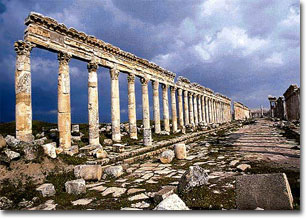
The Colonnaded Street (in Roman Cardo Maximus):
The site falls into several groups of ruins; the main columned street or cardo maximus which 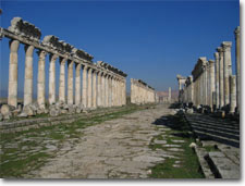 served as the spine of the typically Hippodamian grid pattern. It was later retained by the Romans as the standard layout for their military and other colonies. It is, in its present form, a Roman improvement following the disastrous earthquake of 115. It stretches 1.85 km from north to west, considerably longer than Palmyra (1.2 km) or Damascus (1.35). it was lined with buildings of civic and religious significance. Some of the columns along the colonnade carried brackets, a Syrian practice intended to support statues of civic or imperial dignitaries. served as the spine of the typically Hippodamian grid pattern. It was later retained by the Romans as the standard layout for their military and other colonies. It is, in its present form, a Roman improvement following the disastrous earthquake of 115. It stretches 1.85 km from north to west, considerably longer than Palmyra (1.2 km) or Damascus (1.35). it was lined with buildings of civic and religious significance. Some of the columns along the colonnade carried brackets, a Syrian practice intended to support statues of civic or imperial dignitaries.
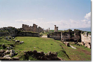
The Agora and the Temple of Zeus Belos:
 It's originally a vast open space behind the main colonnade. The agora (forum - a public square) was approached by two entrances. One colonnaded with seven columns and the other is an eight-column entrance pavilion. The columns were supported on beautifully carved bases, almost Byzantine in their elaboration. It's originally a vast open space behind the main colonnade. The agora (forum - a public square) was approached by two entrances. One colonnaded with seven columns and the other is an eight-column entrance pavilion. The columns were supported on beautifully carved bases, almost Byzantine in their elaboration.
Behind the agora are the remains of the Temple of Zeus Belos, diminished in 384 by order of Bishop Marcellus.
Baths:
They were built in the last year of Tarjan's reign (117 AD), they are lavish in scale with two large halls for the cold and warm baths. It is worth noting for the richer, more classically portentous lines of the columns in this north sector, reflecting the imperial inspiration for this early phase of the project as opposed to the more razzle-dazzle style adopted further south where local influences seem more predominant.
The city was walled before the second century AD, and Justinian rebuilt it after the earthquakes. The walls on the west and north sides are particularly well preserved.
Churches:
- Round Church: dating from Justinian (527 - 65). The church comprised a circular chamber extended out to the east to end in a semi-circular apse.
- The Atrium Church: it's slightly smaller. This church is an enlargement, from Justinian's time, of a fifth century building.
- The Eastern Cathedral: it occupies the next two segments of the city grid to the east. The decumanus marked the monumental entrance to the building. The grand entry court of the cathedral dates from 533. The centralized church is the earliest Christian construction in the cathedral.
The Roman Residences:
Three of the Roman residences were excavated in 1973. The most interesting is the so-called House of Consoles whose façade has been reconstructed on the north side of the grid segment. It is grouped around a large peristyle of six by nine columns. A gallery ran along three sides, the fourth (to the east) opening to a hall through three doors. The middle house is of Pilasters. The rooms are grouped around a peristyled courtyard with the main reception rooms off the courtyard to the north. The third house is less fully excavated.
The Theater:
The theater is found between the cardo and the modern village. Most of its masonry seems to have been carried away to support building activity in the town over the centuries. The theater is mostly dated to the later second century AD.
The Castle - al Madiq Castle:
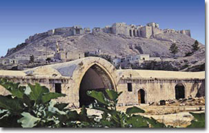 It was in use from Seleucid times and played a particularly important role as an Arab point of defense against the Crusaders. But the few remains of this Arab fortress are largely swallowed by the modern upper village but parts of the outer walls of variegated stonework are Mameluke (13th century). It was in use from Seleucid times and played a particularly important role as an Arab point of defense against the Crusaders. But the few remains of this Arab fortress are largely swallowed by the modern upper village but parts of the outer walls of variegated stonework are Mameluke (13th century).
The Museum:
The Ottoman caravanserai has recently been converted and restored as a museum of mosaics, inscriptions, sarcophagi and statuary, many collected from the region of Apamea.
|

